
The southeast United States is not the only place dealing with flooding and extreme weather. Back at the end of September, iSeeChange user Sarah Horley posted a photo of a road made impassable by brown floodwater.
Unusually heavy rains and associated flooding in a low rainfall area
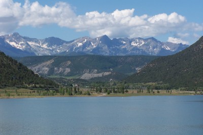
Horley lives in South Australia, in an area of the state that normally has a Mediterranean climate – dry summers and moist, mild winters.
“Heavy rain events are very rare here…until this September!” Horley wrote.
But what she saw next was completely unexpected.
Just two days later, a massive low pressure system swept over the region and birthed tornadoes and thunderstorms that brought down the power grid for all of South Australia.
“The storm produced 2 tornadoes that knocked out the power,” Horley said. She lost power to her home for 12 hours.
“Over 48 hours later,” she added, “some South Australian communities are still without power.”
What led to the extreme weather?
“We have had above average rainfall this spring with below average temperatures,” Horley wrote in an email interview with iSeeChange. “Apple blossoms are only just starting to appear.”
That’s about six weeks later than usual. She also noticed an abundance of little corellas (white cockatoos native to Australia) not usually seen so far south this time of year.
In fact, South Australia’s winter (June through August in the southern hemisphere) was the wettest since 2001, according to the Australian government’s Bureau of Meteorology. Just a week after the power outage, more storms caused heavy floods and winds strong enough to uproot trees.
“Flooding events are a rare occurrence in South Australia, yet recently they have become more normalized.” Horley said.
In an email interview with iSeeChange, Dr. John Allen, an Australian atmospheric scientist and tornado expert, said that connecting the unusually wet and cool weather in South Australia to the storms is difficult – however, wetness and cooler surface temperatures do tend to create favorable conditions for tornadoes.
“[Tornadoes] require low cloud bases, which more moisture allows,” Allen wrote. A tornado forms between the ground and the base of a cloud during the kind of weather system that passed over South Australia.
As for the flooding: “If it has been wet it can often mean a greater risk of runoff in intense rain,” Allen said.
Is climate change a factor?
Allen says the extreme weather can’t be easily linked to climate change – in fact, South Australia has seen its share of such weather in the past.
“The region is susceptible to explosive cyclogenesis,” Allen wrote, citing a paper published in the Journal of Climate in 2010. Explosive cyclogenesis – also known as a “meteorological bomb” – refers to a large weather system in which the air pressure drops drastically over 24 hours, causing massive instability and leading to thunderstorms and extreme weather.
“It’s not unheard of in the Great Australian Bight,” Allen wrote. (The Bight is a body of water off the southern coast of Australia.) “In fact, there is generally one of these type of systems every or every other year.”
He added that the region might see more extreme weather into the spring (through November), and had this advice for iSeeChange users:
“Paying attention to thunderstorm favorable conditions is a usual way to keep up to date with the weather that could produce these events.”
What to look out for
Predicting extreme weather before it happens is something that scientists are still working to improve. While the science of forecasting storms and floods is fairly developed, it’s harder to forecast tornadoes well in advance – a challenge that Allen is trying to solve with other atmospheric scientists.
As we continue to observe and record changes in our environment each day, we can keep an eye out for some early indications that a storm might be coming.
- Note the color of the clouds and the strength of the wind. Clouds that are darkening and building vertically can be a sign of an incoming storm, as can strong winds. Are there layers of clouds moving in different directions?
- Check the air pressure. A drop in pressure implies that a storm isn’t far behind. Does the air feel heavy?
- Observe the animals around you. Is your dog or cat scratching its ears or taking cover? Are birds flying lower to the ground? Animals are particularly sensitive to changes in barometric pressure.
What are some things you’ve observed in your environment that tell you a storm is coming? Post them to iSeeChange, and be sure to let us know if your weather forecast was correct.
And most importantly, make sure to stay safe out there.