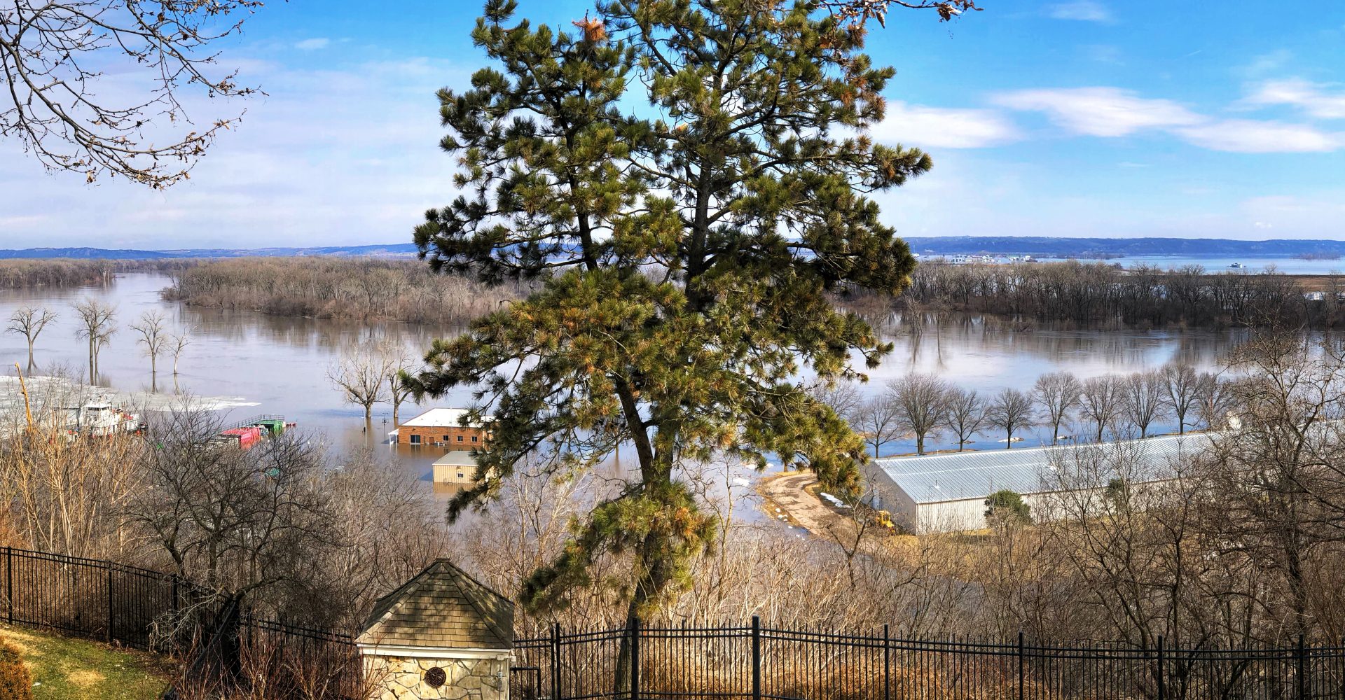
From his home in Hudson, Iowa, Zach Van Stanley watched as the snow-covered cornfield in his backyard flooded on March 14.
“It basically turned into a river in just that afternoon,” he said.
Flooding, from a combination of near-record snowfall melting and from rain.
Van Stanley said that it’s normal to see a little water collecting in the field when the snow melts, but that the level of flooding this year was remarkable.
Compared to other parts of the Midwest, Van Stanley’s town got out easy. Rapidly melting snow caused deadly, and in many places record-breaking, flooding across the region and the northern Great Plains. Bryan Peake, a service climatologist at the Midwest Regional Climate Center, said he couldn’t think of another spring snowmelt event that had ever caused such extreme flooding.
Van Stanley wanted to know: What made this year so bad?
The answer is a perfect storm of factors. The fingerprints of mid-March flooding in the area can be traced back to the summer of last year and the wet months that followed. Some of the root causes — like wetter weather and rapid spring warm ups — have become more likely due to climate change.
“Having frozen ground, having snow on the ground, having moderate to heavy rainfall,” Peake said, “all those things together made it so that the snowmelt and the spring flooding was so much worse.”
The rains started last summer
Late last summer, heavy rainstorms flooded rivers and lakes and saturated soils throughout the Midwest and northern Great Plains. Rainy weather continued through the fall.
Climate change has made wet weather more common in the area. Since 1991, annual precipitation in the Midwest has increased, according to the Fourth National Climate Assessment. Additionally, intense rainstorms have become more common.
“The Midwest as a whole went into the winter season with very little to no drought,” Peake said. “Basically, that means when you get a lot of precipitation in those winter months, that’s just going to exacerbate any type of spring flooding.”
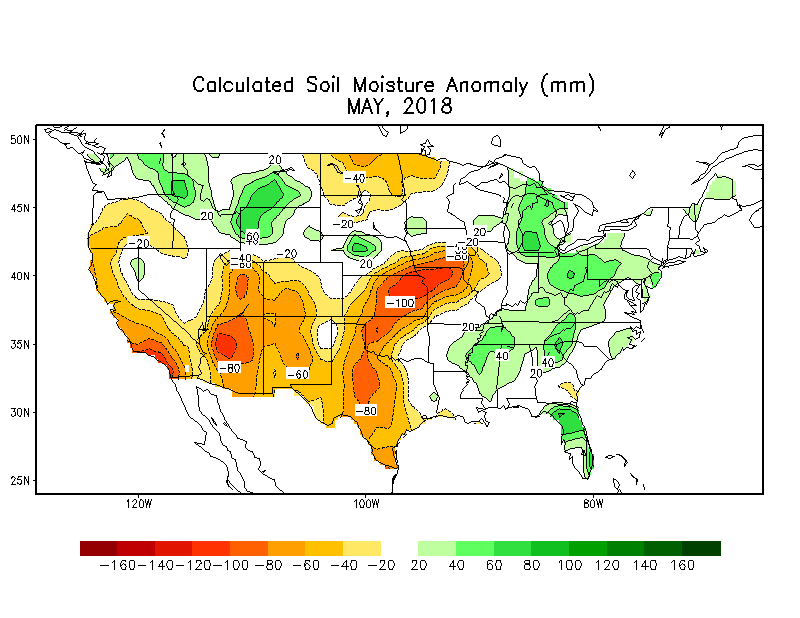
Map source: The National Weather Service
When winter came, wet soils froze rock-solid
Because of the wet autumn, there was plenty of water in the soil to freeze during winter. Wet soil takes longer to freeze than dry soil, but when it does, it seals tight — like the surface of a frozen pond — and makes it difficult for anything to pass through.
“Saturated soil versus a dry soil, when they freeze they actually have very different permeability,” said Yuxin Wu, a research scientist at the Lawrence Berkeley National Laboratory. “In the wet soil, you have this ice form between the soil particles.”
In December and January, the Midwest had low snowfall totals, so in many places there was not much snowpack to insulate the ground. Additionally, an outbreak of Arctic air swept down into the Plains and Midwest at the end of January. From January 30-31, the temperature in northern Minnesota dove to -56°F, Chicago fell to -23°F, and Waterloo, Iowa, near where Van Stanley lives, broke records with a low of -31°F.
In some areas, that led to a phenomenon called ice quakes, when moisture in the soil expands as the water turns to ice, causing loud, cracking booms. I heard some at my house in southern Wisconsin:
Frozen soils became a problem in mid-March when air temperatures warmed rapidly and melted snow while the soil took time to thaw. On March 13, soil temperatures were still at or below freezing, said Peake, leaving the ground essentially impenetrable and snowmelt with nowhere to go.
Even in warmer areas without frozen ground, the soil was so saturated that it couldn’t absorb much water. As a result, snowmelt and rain ran through watersheds quickly and overwhelmed creeks, rivers and flooded nearby communities and farms.
Im at French Lick and at the West Baden Hotel and it’s flooded
Record-breaking snowfalls dumped moisture on hard ground
February followed January’s cold with record-breaking snowfall throughout the heartland and relatively persistent cold that, in most places, kept the snow around. The weather station in Waterloo broke the snowfall record set in 1962 by 6.8 inches.
“If we had the same amount of snowfall, say spread out throughout the winter when you have normal freeze and thaw cycles, and snowmelt, and evaporation, maybe this wouldn’t be as big of an issue,” Peake said. In other words, had snow fallen gradually instead of all in one month, snow totals on the ground would have been lower and there would have been less runoff.
The impact of climate change on snowfall in the Midwest and Plains is uncertain, but projections suggest that heavy snow events will become more likely in the northern Great Plains.
David Robinson, a professor at Rutgers University who manages the Global Snow Lab, said that in some areas where climate change causes winter temperatures to warm above freezing more often, more winter precipitation may fall as rain. But other areas may experience more snow.
“As the cold temperatures get closer to freezing, there’s more moisture being held by the atmosphere,” he said. “So ironically, there are some areas that should warm up and get snowier because the temperatures will still be below freezing.”
Then the ‘bomb cyclone’ happened
With piles of snow on the ground on March 13, a “bomb cyclone,” a rapidly forming low-pressure area, brought high winds and heavy rain to Nebraska, Iowa and parts of southern Wisconsin. March rain events are not uncommon in the area, Peake said, but since the bomb cyclone rain fell on top of a deep snowpack, it contributed to severe flooding.
This winter, Heidi Steltzer, a biology professor at Fort Lewis College, studied the impact of rain storms on snow in field experiments with her students. They found that, at least on powdery snow, light rain tends to roll off without sinking in, while heavy rain penetrates into the snow and causes it to melt quicker.
That suggests that heavy rain in parts of the Midwest and northern Plains may have sped up snowmelt and added to runoff that caused flash flooding and river flooding.
They learned that we were just below the snowline, so we got rain and rainbows (students and I are on the hunt for a photo of the winter rainbow; I missed taking one as it came and went fast) and just up valley from us was snow, really wet snow. Feels more AK, than CO right now.
So, we measured humidity, which was 40% today, and then began learning about how humidity affects snow ablation. Students (and I) looked up ablation to make sure we were understanding correctly that this is the combined effect of many ways snow is lost. When snow is gone, melting is important but so too is loss to the atmosphere. https://www.pnas.org/content/pnas/115/6/1215.full.pdf
Look for their posts as they tell the story best about how what we saw today couldn’t have been simulated in any of the experiments we’ve set up the past few weeks. To learn about rain on snow, it, well, it needs to rain on snow.
More danger ahead
The risk of flooding isn’t expected to let up anytime soon. For the first time since the U.S. Drought Monitor started reporting data, the entire Midwest climate region has been free of drought for four consecutive weeks starting February 26. Soil moisture is high, there’s more snow yet to melt in the upper Midwest, and climate change has made spring an increasingly wet season in the region.
In his yard in Iowa, Van Stanley said he could hear the water bubbling in the thawing ground.
“We need a dry stretch more than anything right now,” Peake said. “With soils at or near capacity, the threat of flooding just from routine thunderstorms is there.”
Document flood risk year round!
The weather you see now may have big implications for what the next few months, and even the entire year may look like.
From soil moisture and river levels, to ocean temperatures and high tides, we are working on ongoing projects to incorporate data sets into ISeeChange that can help you understand your community’s flood risk. But we need your help.
If your lawn is squishy, tell us.
If spring feels rainier than normal, collect & post rain gauge data.
If tidal flooding seems higher than ever before, post a photo.
Any insight you can share into the weather in your community can help us create a strong understanding of the issues you face, which can help you and your neighbors advocate for solutions.
Stay tuned for new ISeeChange features coming soon and get posting!
Story by Samantha Harrington for ISeeChange in Partnership with Yale Climate Connections
Cover photo by Photo by Shelby L. Bell.