
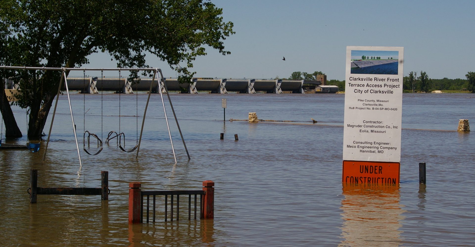
Living near the Mississippi River means keeping an eye trained on the water level. That’s something DeAnna Bell in O’Fallon, Illinois, knows all too well. Bell, who was trapped by floodwaters during the record-breaking flood of 1993, has watched again and again as water engulfed her area. In the spring of 2019, record snowmelt and heavy rain conspired to keep her region under threat of flooding well into the fall.
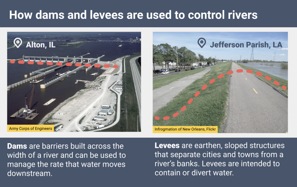
Across the Midwest, river flooding is controlled primarily by dams and levees. But rainstorms in the region are growing more intense as the climate changes, while aging infrastructure is cracking and crumbling. That could require communities along the river banks to try new approaches to flood control — or even to relinquish it.
For Bell and others in the region, frustrations over flood control infrastructure abound. “People have no clue of how to get things fixed,” she said.
The risks of outdated infrastructure
Many of the dams and levees across the U.S. are outdated and at risk of failing. According to a 2017 infrastructure report card published by the American Society of Civil engineers, seven out of 10 dams will be older than 50 years by 2025. An estimated 30% of dams were found to have a hazard potential that was either “significant,” meaning there was a risk of damage or “high,” meaning there was a risk of loss of life.
Many levees are privately owned, which makes their status more difficult to study. But according to the report card, of the 1,200 levees assessed by the U.S. Army Corp of Engineers, 20% were found to be moderate to high risk.
The rain is eroding the banks of the river.
— Zoe B
Investment in updating aging and broken river flood control is limited. In its Infrastructure Report Card, the American Society of Civil Engineers reported that $45 billion is needed to rehabilitate the country’s dams but that only $5.4 billion in funding was available in 2017. Along Midwestern riverways, some infrastructure damaged by flooding in 2019 remains in disrepair.
“High river levels persisted in some areas almost the entire year in 2019, preventing access to even evaluate what damage had been sustained, which is the first step in the repair process,” said John Osterhage, chief of emergency management for the U.S. Army Corps of Engineers’ St. Louis District.
But even if failing river infrastructure is repaired, climate change could soon undo that progress.
River flood control isn’t always designed for climate change
Designing dams and levees for effective flood control is not an easy task, as precipitation and the consequent river flow can be unpredictable. In the U.S., the average lifespan of a dam is expected to be 50 years. But five decades from now, the climate may be quite different from how it has been, kicking unpredictability up a notch.
Scientists expect that climate change will continue to increase the number and severity of heavy rainstorms in some U.S. regions, but they’re still uncertain about the specific details like how much and how often. Some parts of the U.S., like the Southwest, are expected to see less rain than in the past, while others, such as the Northeast and Midwest, are expected to receive more rain. According to the Fourth National Climate Assessment, the amount of rain falling in the heaviest storms in the Midwest is expected to increase by 40% by 2070–2099 relative to recent decades.
Don Duncan, chief of the hydraulics and hydrology branch of the U.S. Army Corps of Engineers’ St. Louis District, said that for the past several years the Mississippi River has experienced higher stream flows during every season.
“This primes the river to more easily rise to levels not commonly seen in the past, even with normal rainfall,” he said. “Heavy storms will result in even more extreme flooding.”
Baptiste François, a professor of civil and environmental engineering at the University of Massachusetts, Amherst, said that flood-control design often relies on historical records of past flooding. This is the idea of stationarity — that designers can assume that river flows will fall within the same extremes of high and low river levels that have been seen in the past. Yet researchers have actively been discussing the “death” of stationarity as an engineering principle in the era of climate change:
“You have to kind of assume that statistics of your streamflow distribution won’t change in time,” François said. “That’s a big challenge. First, we have some understanding about the climate science that basically tells us that the assumption of stationarity might no longer be true.”
At the moment, flood control design guidelines in the U.S. do not require designers to incorporate climate change into their work. In 2015, the Obama Administration issued an executive order requiring flood risk assessments to be informed by climate science, but the Trump Administration rescinded it in August of 2017.
François said that many engineering companies are reluctant to try new design strategies, which they see as riskier than designing as usual.
“Let’s say if we introduce non-stationarity and we build a levee twice the size of what it should be,” he said. “If the flood distribution doesn’t change, people will blame that because it created a much more expensive project.”
How might flood control be designed for climate change?
Rather than building enormous projects in the face of increased flooding, some places are trying a counterintuitive strategy — relinquishing some control of the river.
In the Netherlands, for example, the government implemented a practice known as “Room for the River.” Leaving room for rivers is accomplished by a variety of strategies, such as placing levees farther back from the banks or the river — or not building in the floodplain at all. That enables wetlands to occupy a larger area, which can reduce the impacts of flooding.
“These efforts can be challenging to implement on heavily managed rivers like the Mississippi, because it would require the purchase of large amounts of land from private landowners and large investments in a new levee system,” said Samuel Muñoz, an assistant professor of marine and environmental engineering at Northeastern University.
But some communities along the Mississippi have already tried an approach more along the lines of Room for the River. In Iowa, the city of Davenport has long managed flooding without levees or flood walls, the only major city along the Mississippi to do so. Along the river’s edge, parks and public spaces are designed to handle inundation. A baseball stadium in the park even becomes an island when the river is high.
Such strategies may also save money in the long term. Rural Jersey County, Illinois, for example, suffered a high rate of repeat flood losses in the 1990s. In subsequent years, the county bought out some properties and elevated others. A study by the Army Corps found that conservatively, the county had avoided $2.89 of losses every $1 spent on mitigation, according to Hal Graef, a project manager in the Corps’ St. Louis District.
Leaving room for the river does not always work perfectly, particularly during major floods. Davenport was hit hard by the 2019 spring flooding and many community members wondered if the city should install a flood wall. And buying out and elevating properties would be difficult and expensive in urban areas.
But according to Muñoz, traditional flood control strategies like dams and levees can be more harmful than helpful in some cases. His research found that engineering projects along the lower Mississippi worsened flooding by transforming it from a meandering river to a direct and confined channel. This “artificial channelization” can speed up the rate of water moving downstream during flooding and increase the peak amount of water discharged during a flood.
“If at all possible, make room for the river so that it can periodically flood without devastating your community,” he said. “Investing heavily in aggressive river engineering tends to bring about unintended consequences, and in the long-term may cost more than initially planned.”
As infrastructure continues to age and climate change heightens flood risk, communities will need to make difficult decisions about whether rebuilding their old dams or levees is the best approach. For now, for DeAnna Bell, the best way to manage living near the river is to stay aware of the weather and stay connected to one’s community.
“Watch the weather reports, watch the river stages and be prepared to get out if you have to,” she said. “Know your neighbors if you live in a flood area, and don’t be afraid to ask for help.
Post about your summer
How has the weather been in your area? Tell us about how your daily life is impacted by heat waves, summer storms, bug bites and more.
Story by Samantha Harrington for ISeeChange in Partnership with Yale Climate Connections.
Cover photo by eagle102.net via Flickr.