By Aaron J. DeMayo, Future Vision Studios
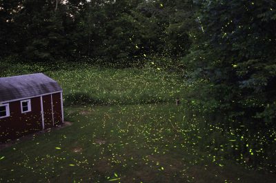
Patterns are found throughout nature, some are visually apparent, and others can be found over cycles following the lunar or a calendar year. Tools like ISeeChange create and enable citizen scientists to track, share, and learn about consistencies and variations occurring within their communities. The new data points being made in real-time, and the references to historical norms, provides an opportunity to understand the changes happening and co-design infrastructure solutions with municipalities more holistically and comprehensively. As data is filled in over years patterns emerge, we are finding that tidal predictions by NOAA at Virginia Key are consistently less than actual tidal heights due to sea level rise and that tidal predictions do not account for actual weather and current conditions.
Miami and Miami Beach, Florida, have the most real estate assets by value at risk to sea level rise on Earth. South Florida also faces threats from climate change including heavy precipitation events, extreme flooding, sunny day flooding, storm surge damage, increased heat island effects, ecosystem degradation, and flora and fauna loss all of which can be tracked on ISeeChange.
Over the last few years, as flooding has become more extensive and frequent, people have taken to social media to share the results. These fleeting posts are rarely tracked with accurate geolocations, let alone categorized. ISeeChange has enabled anyone and everyone to share their perspective and detailed observations with a global community in real-time. In Miami, posts are viewed directly by City of Miami staff who can then address issues as they occur, or save the information for planning purposes.
If you or your community has a question or hypothesis about how climate is changing your area, you can create an ISeeChange account to collect data and ask those questions to your community, elected officials, and local government. Create an account and post a sighting. The best posts combine detailed stories and photos to show what you’re seeing in your environment and how it affects you.
I have been filming and photographing the effects of climate change in Miami regularly since 2015. ISeeChange allows me to post events that previously occurred, the application automatically layers additional weather statistics synced to each post and event that can be tracked by geographic location over time. As an architectural designer and urban planner producing solutions to adapt to climate change within South Florida, seeing the data points from the posts I created, other community members’ observations, and the additional metadata added by the application helps me understand the patterns to plan projects more successfully.
Another helpful feature is that while I may be capturing the results of a storm in one neighborhood, I can view other users’ posts showing how that same storm affected other areas. Our cities are complex and interconnected. Heavy rain in one location can impact the stormwater system in another.
Miami has many low-lying areas, including the very dense Edgewater neighborhood, occupying the top third of Miami’s Downtown Urban Core. The area’s topography tapers from high ground along the railroad tracks to the west, down toward the water’s edge at Biscayne Bay on the east.
Many problematic areas flood within Edgewater from rain events, sunny day flooding, or both. East of Biscayne Boulevard, NE 22nd Street to NE 24th Street has had flooding problems for years and has become worse.

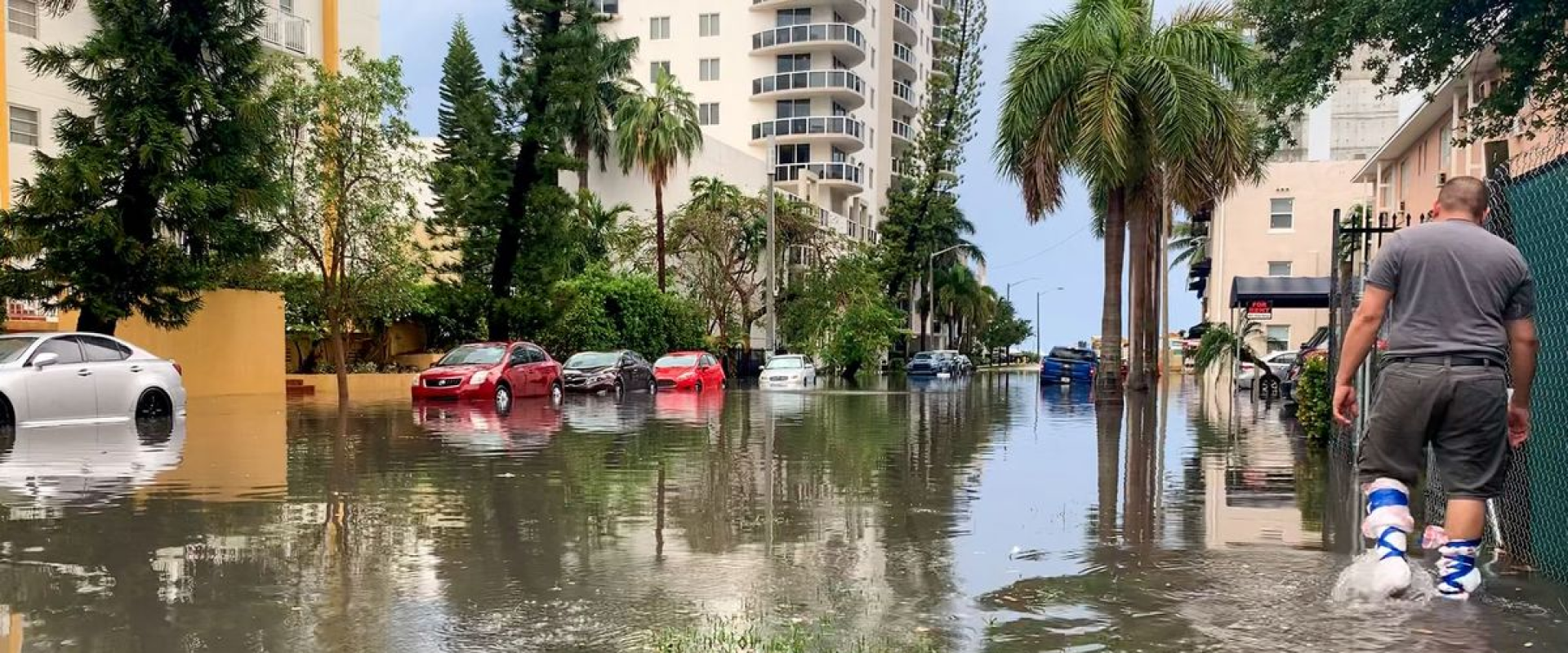
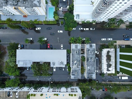
The most recent storm event I captured on November 5th, saw flooding inundating all three blocks, including locations that I had previously never witnessed flooding before. There was a King Tide as well as rain that day. The aerial image below shows the scale of this event, with multiple cars stranded and abandoned in the middle of the street, and dirty black water encircling many mulit-family housing buildings.
During King Tides, a moment when the earth, the moon, and the suns’ arrangement along with seasonal winds drive the tides higher, there is often significant flooding within the streets and public right-of-way at this location. The street can become inundated with over a foot of water that extends from one building edge to the other, making the road and sidewalks nearly impassable for pedestrians and most vehicles, such as on October 1st, 2019. Seasonal winds, atmospheric pressure, and ocean temperatures also influence the tides. Tides in Miami are typically highest from Mid-September to Mid-November.
Observed October 01, 2019:
— Aaron DeMayo
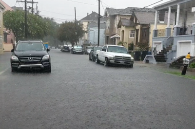
Other times, it is a nuisance, as it begins and subsides within about an hour of the peak tide and is not high enough to disrupt vehicular or pedestrian movement too much, as seen on October 28th, 2019. However the corrosive salt water can still damage vehicles and kill plants and animals. In the image below it is visible that the grass has become brown from repeated salt water flooding.
Observed October 28, 2019:
— Aaron DeMayo
During the higher King Tide events or more significant rainstorms, the flooding disrupts people from leaving or getting to their homes, significantly interrupting their quality of life. Lola writes, “Our street is completely flooded. Cars get stuck in the water all the time and have to get towed truck because it’s just so bad. People can’t even walk in the street without getting completely wet. Some people that have to park in the street can’t even get in their cars because the water is so high that if they open the car door, the inside will be completely flooded with water.”
— Lola !
Cars parked along the on-street spaces can be flooded with corrosive salt water during king tide events, or dirty water from large storm events, damaging the mechanical components, and interiors. The economic damage to vehicles, public and private property, and increase in insurance claims or increased insurance policies negatively affects residents, guests, and the city’s economy. The residents and guests along NE 23rd Street know this far too well. On multiple instances I have seen residents rush to their vehicles to move the car down the street to higher ground as soon as a storm begins. On April 26th 2020, a resourceful resident who acted quickly to move his vehicle wrapped his feet in garbage bags to keep his legs dry while he waded through the dirty water to get back to his home.
Observed on April 26, 2020:
— Aaron DeMayo
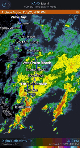
The storms regularly wash pollution from the street into the bay. Construction sites have also come under scrutiny as the uncovered sediment has continually been washed into Biscayne Bay during rain events, further straining the fragile and already significantly damaged marine ecosystem.
Observed on November 5, 2021
— Aaron DeMayo
The dirty stormwater from upstream has been forced out onto the street in the topographically low areas from the stormwater drains and maintenance hole covers. On April 30th, water was seen gushing 4’ above the street.
Observed on April 30, 2020:
— Aaron DeMayo
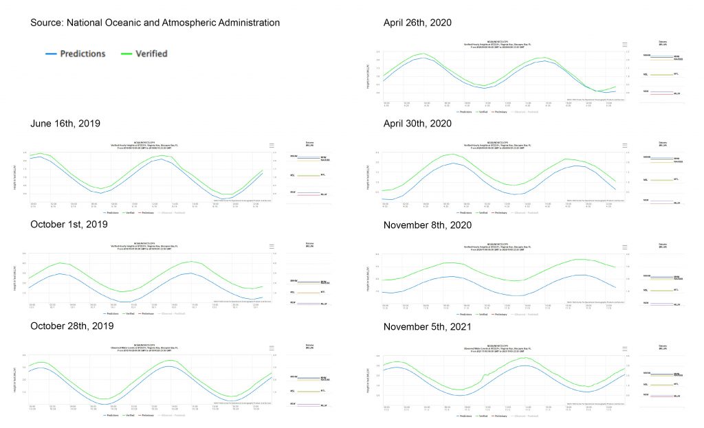
During each of the seven flooding events I captured in this location over the last thirty months including rain and sunny day flooding events, the NOAA predicted tidal level was lower than the actual verified tidal height at Virginia Key, where the closest gauge is located. In some cases, the predicted height was a few inches lower, in other cases, over 18”.
Brian McNoldy, Senior Research Associate at the University of Miami’s Rosenstiel School, said, “Modern sea level is about six inches higher than the 1983-2001 baseline used in the NOAA Tide Predictions.” Also the existing “tide predictions do not account for actual weather and current conditions.”
McNoldy and Dr. Brian Soden are supervising a project with Senior Undergraduate student Nate Taminger to better forecast conditions.
“They use modern sea level offset, and also account for forecast changes in surface pressure, wind, and offshore swell energy,” McNoldy said.
The graphs below illustrate the predicted tidal height in a blue line and the actual in green for each of those seven occurrences that I captured on NE 23rd Street in Edgewater. It is clear that McNoldy and his team’s work is greatly needed so our community can be more prepared with better data for future conditions.
As the climate warms, sea levels rise, and the atmosphere holds more water, the lack of certainty for predicting flooding events may become more significant. The data created from the community on the ISeeChange application allows for a better understanding of actual events, leading to better planning for the future.
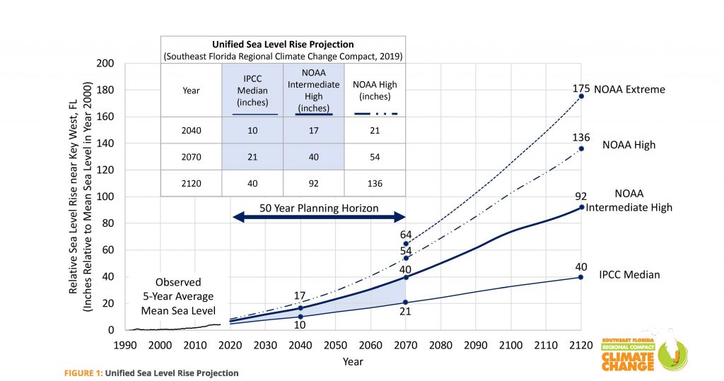
Without interventions, these events will further disrupt the neighborhood more extensively. The Unified Sea Level Rise Projection by NOAA median is 10 inches by 2040 and the Intermediate High projection is seventeen inches.
Various solutions can be utilized based on the specific context, zoning, density, topography, right-of-way dimensions, funding, and communities’ preferences, among many other factors. For the location of NE 22nd to 25th Streets The City of Miami is in the process of updating the stormwater system with a new pump station, new pipes and a proposed force main. They are proposing offline externally bypassed filtration units that should be able to handle the peak flow rates from large storm events that appear to be inundating this area.
In the near future the road will most likely need to be raised. Bio-swales that catch and retain water can also create space to plant trees that will grow shade canopy, reducing the heat island effect, adding beauty, creating habitats for animals, boosting people’s happiness, and increasing property values.
Tracking the patterns occurring in our environment through ISeeChange allows us to understand that the past Miami we knew is no longer here. A hotter, wetter, more resilient Miami is on the horizon. We have the technology and an active community working together to understand what is happening and discuss how changes lead to opportunities for a better tomorrow. The cities that thrive in the twenty-first century are where people most accurately perceive their environment and successfully adapt to it.
Aaron DeMayo
Principal, Future Vision Studios